

US Arkansas Election Result 2016 Live By County Republican Democrats , Arkansas Candidates list, Arkansas Opinion Poll 2016, US Presidential Arkansas election Results, Arkansas Past election Results, Arkansas Election Updates Exit Poll, Arkansas Schedule/Dates, Who will win in Arkansas Primary/Caucus, USA Presidential election, Arkansas Republican Democratic Vote Swing, Arkansas Republican Candidate
Presidential Elections 2020, US Election Result November 17, 2015,US Arkansas Election Result 2016 Live By County Republican Democrats , Arkansas Candidates list, Arkansas Opinion Poll 2016, US Presidential Arkansas election Results, Arkansas Past election Results, Arkansas Election Updates Exit Poll, Arkansas Schedule/Dates, Who will win in Arkansas Primary/Caucus, USA Presidential election, Arkansas Republican Democratic Vote Swing, Arkansas Republican Candidate
Arkansas election result analysis with vote percentage and margin is shown with vote swing achieved by Democratic and Republican Candidate. Latest Election Updates, Opinion/Exit Poll, Candidate list, Election Result 2016, Schedule.
US Arkansas Election Result 2016 Live By County
|
2016 Arkansas Presidential Election Results |
|||
|
100% Reporting Electoral Votes: 6 |
|||
|
Polls Closing: 8:30 PM ET |
Electoral Votes |
||
|
R Winner D. Trump |
60.40% |
6,77,904 |
6 |
|
D H. Clinton |
33.80% |
3,78,729 |
|
|
2016 Arkansas Presidential Election Results by County |
|||
|
Arkansas County |
|||
|
100% Reporting |
|||
|
R D. Trump |
61.60% |
3,825 |
|
|
D H. Clinton |
31.20% |
1,939 |
|
|
Ashley County |
|||
|
100% Reporting |
|||
|
R D. Trump |
66.00% |
5,338 |
|
|
D H. Clinton |
29.80% |
2,408 |
|
|
Baxter County |
|||
|
100% Reporting |
|||
|
R D. Trump |
74.30% |
14,655 |
|
|
D H. Clinton |
21.10% |
4,163 |
|
|
Benton County |
|||
|
100% Reporting |
|||
|
R D. Trump |
62.90% |
60,751 |
|
|
D H. Clinton |
28.90% |
27,894 |
|
|
Boone County |
|||
|
100% Reporting |
|||
|
R D. Trump |
75.90% |
12,225 |
|
|
D H. Clinton |
18.20% |
2,925 |
|
|
Bradley County |
|||
|
100% Reporting |
|||
|
R D. Trump |
59.20% |
2,163 |
|
|
D H. Clinton |
36.10% |
1,317 |
|
|
Calhoun County |
|||
|
100% Reporting |
|||
|
R D. Trump |
68.60% |
1,554 |
|
|
D H. Clinton |
28.10% |
636 |
|
|
Carroll County |
|||
|
100% Reporting |
|||
|
R D. Trump |
63.10% |
6,773 |
|
|
D H. Clinton |
31.10% |
3,334 |
|
|
Chicot County |
|||
|
100% Reporting |
|||
|
D H. Clinton |
56.30% |
2,350 |
|
|
R D. Trump |
41.10% |
1,716 |
|
|
Clark County |
|||
|
100% Reporting |
|||
|
R D. Trump |
51.70% |
4,398 |
|
|
D H. Clinton |
42.40% |
3,606 |
|
|
Clay County |
|||
|
100% Reporting |
|||
|
R D. Trump |
63.00% |
3,779 |
|
|
D H. Clinton |
33.30% |
1,999 |
|
|
Cleburne County |
|||
|
100% Reporting |
|||
|
R D. Trump |
78.30% |
9,454 |
|
|
D H. Clinton |
17.40% |
2,101 |
|
|
Cleveland County |
|||
|
100% Reporting |
|||
|
R D. Trump |
73.40% |
2,460 |
|
|
D H. Clinton |
21.60% |
723 |
|
|
Columbia County |
|||
|
100% Reporting |
|||
|
R D. Trump |
61.40% |
5,456 |
|
|
D H. Clinton |
35.30% |
3,140 |
|
|
Conway County |
|||
|
100% Reporting |
|||
|
R D. Trump |
61.20% |
4,844 |
|
|
D H. Clinton |
33.50% |
2,655 |
|
|
Craighead County |
|||
|
100% Reporting |
|||
|
R D. Trump |
64.40% |
22,798 |
|
|
D H. Clinton |
29.60% |
10,474 |
|
|
Crawford County |
|||
|
100% Reporting |
|||
|
R D. Trump |
74.30% |
16,655 |
|
|
D H. Clinton |
20.00% |
4,476 |
|
|
Crittenden County |
|||
|
100% Reporting |
|||
|
D H. Clinton |
52.60% |
8,368 |
|
|
R D. Trump |
43.70% |
6,953 |
|
|
Cross County |
|||
|
100% Reporting |
|||
|
R D. Trump |
66.70% |
4,577 |
|
|
D H. Clinton |
29.10% |
1,995 |
|
|
Dallas County |
|||
|
100% Reporting |
|||
|
R D. Trump |
54.40% |
1,507 |
|
|
D H. Clinton |
42.10% |
1,165 |
|
|
Desha County |
|||
|
100% Reporting |
|||
|
D H. Clinton |
52.40% |
2,227 |
|
|
R D. Trump |
45.00% |
1,915 |
|
|
Drew County |
|||
|
100% Reporting |
|||
|
R D. Trump |
60.20% |
3,967 |
|
|
D H. Clinton |
35.90% |
2,364 |
|
|
Faulkner County |
|||
|
100% Reporting |
|||
|
R D. Trump |
61.80% |
29,170 |
|
|
D H. Clinton |
30.80% |
14,525 |
|
|
Franklin County |
|||
|
100% Reporting |
|||
|
R D. Trump |
74.40% |
5,034 |
|
|
D H. Clinton |
20.30% |
1,376 |
|
|
Fulton County |
|||
|
100% Reporting |
|||
|
R D. Trump |
72.70% |
3,470 |
|
|
D H. Clinton |
22.40% |
1,067 |
|
|
Garland County |
|||
|
100% Reporting |
|||
|
R D. Trump |
64.00% |
26,053 |
|
|
D H. Clinton |
30.20% |
12,283 |
|
|
Grant County |
|||
|
100% Reporting |
|||
|
R D. Trump |
74.70% |
5,160 |
|
|
D H. Clinton |
20.40% |
1,407 |
|
|
Greene County |
|||
|
100% Reporting |
|||
|
R D. Trump |
73.50% |
10,698 |
|
|
D H. Clinton |
21.00% |
3,056 |
|
|
Hempstead County |
|||
|
100% Reporting |
|||
|
R D. Trump |
62.50% |
4,391 |
|
|
D H. Clinton |
33.70% |
2,371 |
|
|
Hot Spring County |
|||
|
100% Reporting |
|||
|
R D. Trump |
68.50% |
8,153 |
|
|
D H. Clinton |
26.30% |
3,137 |
|
|
Howard County |
|||
|
100% Reporting |
|||
|
R D. Trump |
67.50% |
3,155 |
|
|
D H. Clinton |
28.90% |
1,350 |
|
|
Independence County |
|||
|
100% Reporting |
|||
|
R D. Trump |
73.00% |
9,925 |
|
|
D H. Clinton |
21.20% |
2,878 |
|
|
Izard County |
|||
|
100% Reporting |
|||
|
R D. Trump |
74.20% |
4,042 |
|
|
D H. Clinton |
20.40% |
1,111 |
|
|
Jackson County |
|||
|
100% Reporting |
|||
|
R D. Trump |
63.30% |
3,262 |
|
|
D H. Clinton |
30.70% |
1,583 |
|
|
Jefferson County |
|||
|
100% Reporting |
|||
|
D H. Clinton |
60.90% |
15,721 |
|
|
R D. Trump |
35.70% |
9,231 |
|
|
Johnson County |
|||
|
100% Reporting |
|||
|
R D. Trump |
66.80% |
6,072 |
|
|
D H. Clinton |
26.60% |
2,421 |
|
|
Lafayette County |
|||
|
100% Reporting |
|||
|
R D. Trump |
61.50% |
1,750 |
|
|
D H. Clinton |
36.10% |
1,028 |
|
|
Lawrence County |
|||
|
100% Reporting |
|||
|
R D. Trump |
71.50% |
4,064 |
|
|
D H. Clinton |
22.20% |
1,263 |
|
|
Lee County |
|||
|
100% Reporting |
|||
|
D H. Clinton |
57.50% |
1,735 |
|
|
R D. Trump |
40.70% |
1,229 |
|
|
Lincoln County |
|||
|
100% Reporting |
|||
|
R D. Trump |
64.20% |
2,455 |
|
|
D H. Clinton |
32.70% |
1,252 |
|
|
Little River County |
|||
|
100% Reporting |
|||
|
R D. Trump |
68.30% |
3,604 |
|
|
D H. Clinton |
26.50% |
1,397 |
|
|
Logan County |
|||
|
100% Reporting |
|||
|
R D. Trump |
72.50% |
5,737 |
|
|
D H. Clinton |
21.60% |
1,712 |
|
|
Lonoke County |
|||
|
100% Reporting |
|||
|
R D. Trump |
73.70% |
19,902 |
|
|
D H. Clinton |
20.90% |
5,638 |
|
|
Madison County |
|||
|
100% Reporting |
|||
|
R D. Trump |
72.00% |
4,917 |
|
|
D H. Clinton |
23.20% |
1,587 |
|
|
Marion County |
|||
|
100% Reporting |
|||
|
R D. Trump |
74.90% |
5,077 |
|
|
D H. Clinton |
20.30% |
1,377 |
|
|
Miller County |
|||
|
100% Reporting |
|||
|
R D. Trump |
70.20% |
11,293 |
|
|
D H. Clinton |
26.60% |
4,273 |
|
|
Mississippi County |
|||
|
100% Reporting |
|||
|
R D. Trump |
53.40% |
6,988 |
|
|
D H. Clinton |
43.00% |
5,621 |
|
|
Monroe County |
|||
|
100% Reporting |
|||
|
R D. Trump |
50.40% |
1,400 |
|
|
D H. Clinton |
46.70% |
1,298 |
|
|
Montgomery County |
|||
|
100% Reporting |
|||
|
R D. Trump |
74.10% |
2,573 |
|
|
D H. Clinton |
21.20% |
735 |
|
|
Nevada County |
|||
|
100% Reporting |
|||
|
R D. Trump |
61.70% |
2,001 |
|
|
D H. Clinton |
35.60% |
1,156 |
|
|
Newton County |
|||
|
100% Reporting |
|||
|
R D. Trump |
76.60% |
2,875 |
|
|
D H. Clinton |
18.60% |
699 |
|
|
Ouachita County |
|||
|
100% Reporting |
|||
|
R D. Trump |
53.90% |
5,347 |
|
|
D H. Clinton |
43.50% |
4,320 |
|
|
Perry County |
|||
|
100% Reporting |
|||
|
R D. Trump |
69.90% |
2,979 |
|
|
D H. Clinton |
24.30% |
1,035 |
|
|
Phillips County |
|||
|
100% Reporting |
|||
|
D H. Clinton |
61.90% |
4,292 |
|
|
R D. Trump |
35.20% |
2,443 |
|
|
Pike County |
|||
|
100% Reporting |
|||
|
R D. Trump |
79.10% |
3,150 |
|
|
D H. Clinton |
17.20% |
684 |
|
|
Poinsett County |
|||
|
100% Reporting |
|||
|
R D. Trump |
59.10% |
3,149 |
|
|
D H. Clinton |
35.20% |
1,878 |
|
|
Polk County |
|||
|
100% Reporting |
|||
|
R D. Trump |
80.40% |
6,606 |
|
|
D H. Clinton |
14.70% |
1,210 |
|
|
Pope County |
|||
|
100% Reporting |
|||
|
R D. Trump |
72.10% |
15,694 |
|
|
D H. Clinton |
22.10% |
4,818 |
|
|
Prairie County |
|||
|
100% Reporting |
|||
|
R D. Trump |
72.80% |
2,503 |
|
|
D H. Clinton |
23.60% |
812 |
|
|
Pulaski County |
|||
|
100% Reporting |
|||
|
D H. Clinton |
56.00% |
89,377 |
|
|
R D. Trump |
38.40% |
61,182 |
|
|
Randolph County |
|||
|
100% Reporting |
|||
|
R D. Trump |
70.70% |
4,508 |
|
|
D H. Clinton |
22.30% |
1,425 |
|
|
Saint Francis County |
|||
|
100% Reporting |
|||
|
D H. Clinton |
54.30% |
4,031 |
|
|
R D. Trump |
43.00% |
3,195 |
|
|
Saline County |
|||
|
100% Reporting |
|||
|
R D. Trump |
68.20% |
35,852 |
|
|
D H. Clinton |
25.20% |
13,247 |
|
|
Scott County |
|||
|
100% Reporting |
|||
|
R D. Trump |
78.10% |
2,378 |
|
|
D H. Clinton |
16.60% |
507 |
|
|
Searcy County |
|||
|
100% Reporting |
|||
|
R D. Trump |
79.30% |
2,955 |
|
|
D H. Clinton |
16.10% |
601 |
|
|
Sebastian County |
|||
|
100% Reporting |
|||
|
R D. Trump |
65.20% |
28,769 |
|
|
D H. Clinton |
27.60% |
12,184 |
|
|
Sevier County |
|||
|
100% Reporting |
|||
|
R D. Trump |
71.80% |
3,281 |
|
|
D H. Clinton |
23.50% |
1,075 |
|
|
Sharp County |
|||
|
100% Reporting |
|||
|
R D. Trump |
74.60% |
5,405 |
|
|
D H. Clinton |
20.30% |
1,472 |
|
|
Stone County |
|||
|
100% Reporting |
|||
|
R D. Trump |
73.30% |
4,081 |
|
|
D H. Clinton |
21.40% |
1,189 |
|
|
Union County |
|||
|
100% Reporting |
|||
|
R D. Trump |
62.10% |
10,201 |
|
|
D H. Clinton |
34.50% |
5,667 |
|
|
Van Buren County |
|||
|
100% Reporting |
|||
|
R D. Trump |
73.40% |
5,382 |
|
|
D H. Clinton |
21.10% |
1,547 |
|
|
Washington County |
|||
|
100% Reporting |
|||
|
R D. Trump |
50.80% |
40,418 |
|
|
D H. Clinton |
40.60% |
32,296 |
|
|
White County |
|||
|
100% Reporting |
|||
|
R D. Trump |
75.30% |
21,038 |
|
|
D H. Clinton |
18.50% |
5,157 |
|
|
Woodruff County |
|||
|
100% Reporting |
|||
|
R D. Trump |
52.40% |
1,344 |
|
|
D H. Clinton |
43.50% |
1,117 |
|
|
Yell County |
|||
|
100% Reporting |
|||
|
R D. Trump |
71.60% |
4,600 |
|
|
D H. Clinton |
22.90% |
1,472 |
|
Arkansas Primary Results are as follows for Republicans and Democrats.
Democratic Primary Results 2016
| Arkansas Democratic Primary, 2016 | |||
|---|---|---|---|
| Candidate | Vote % | Votes | Delegates |
| Hillary Clinton | 66.3% | 144,580 | 22 |
| Bernie Sanders | 29.7% | 64,868 | 10 |
Republican Primary Results 2016
| Arkansas Republican Primary, 2016 | |||
|---|---|---|---|
| Candidate | Vote % | Votes | Delegates |
| Donald Trump | 32.8% | 133,144 | 16 |
| Ted Cruz | 30.5% | 123,873 | 15 |
Past Presidential Election Results Party Wise.
|
Arkansas |
||||||||
|
1980 |
1984 |
1988 |
1992 |
1996 |
2000 |
2004 |
2008 |
2012 |
|
R |
R |
R |
D |
D |
R |
R |
R |
R |
*D–Democratic
*R–Republican
ASLO READ: Arkansas Presidential Election Result By County by state by district by party–Find Latest Arkansas Presidential Election Result By County by state by district by party list of counties Population area code Result History Seat Density FIPS Code Voter statistics
Click below on each county to know 2016 2012 2008 US presidential election results, votes , margin, swing ,Winner runner up
| County | State |
| Crittenden | Arkansas |
| Cross | Arkansas |
| Dallas | Arkansas |
| Desha | Arkansas |
| Drew | Arkansas |
| Faulkner | Arkansas |
| Franklin | Arkansas |
| Ashley | Arkansas |
| Baxter | Arkansas |
| Benton | Arkansas |
| Boone | Arkansas |
| Bradley | Arkansas |
| Calhoun | Arkansas |
| Carroll | Arkansas |
| Chicot | Arkansas |
| Clark | Arkansas |
| Clay | Arkansas |
| Cleburne | Arkansas |
| Cleveland | Arkansas |
| Columbia | Arkansas |
| Conway | Arkansas |
| Craighead | Arkansas |
| Crawford | Arkansas |
| Fulton | Arkansas |
| Garland | Arkansas |
| Grant | Arkansas |
| Greene | Arkansas |
| Hempstead | Arkansas |
| Hot Spring | Arkansas |
| Howard | Arkansas |
| Independence | Arkansas |
| Izard | Arkansas |
| Jackson | Arkansas |
| Jefferson | Arkansas |
| Johnson | Arkansas |
| Lafayette | Arkansas |
| Lawrence | Arkansas |
| Lee | Arkansas |
| Lincoln | Arkansas |
| Little River | Arkansas |
| Logan | Arkansas |
| Lonoke | Arkansas |
| Madison | Arkansas |
| Marion | Arkansas |
| Miller | Arkansas |
| Mississippi | Arkansas |
| Monroe | Arkansas |
| Montgomery | Arkansas |
| Nevada | Arkansas |
| Newton | Arkansas |
| Ouachita | Arkansas |
| Perry | Arkansas |
| Phillips | Arkansas |
| Pike | Arkansas |
| Poinsett | Arkansas |
| Polk | Arkansas |
| Pope | Arkansas |
| Prairie | Arkansas |
| Pulaski | Arkansas |
| Randolph | Arkansas |
| Saint Francis | Arkansas |
| Saline | Arkansas |
| Scott | Arkansas |
| Searcy | Arkansas |
| Sebastian | Arkansas |
| Sevier | Arkansas |
| Sharp | Arkansas |
| Stone | Arkansas |
| Union | Arkansas |
| Van Buren | Arkansas |
| Washington | Arkansas |
| White | Arkansas |
| Woodruff | Arkansas |
| Yell | Arkansas |
| OTHER IMP LINKS:- |
| US County Result |
| US Election Result |
| Clinton Schedule |
| Trump Schedule |
| US County List |
| US Election Dates |
| State Opinion Poll |
| Nation Opinion Poll |
Following is an analysis of Past Election Results. We have taken out a swing by substracting vote % received in 2008 from that received in 2012 for each party. This shows the positive and negative swing for a particular Party in that state.
|
State
|
Party
|
Swing/Margin
(2012-2008) |
Result
|
|
Arkansas
|
Republican
|
1.85
|
Increased
|
|
Arkansas
|
Democrat
|
-1.99
|
Decreased
|
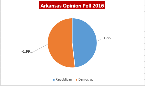
|
Year
|
State
|
Name
|
Party
|
Total Vote
|
General %
|
Status
|
|
|
2008
|
Arkansas
|
McCain, John
|
Republican
|
638,017
|
58.72%
|
Winner
|
|
|
2008
|
Arkansas
|
Obama, Barack
|
Democrat
|
422,310
|
38.86%
|
Runner Up
|
|
|
2008
|
Arkansas
|
Nader, Ralph
|
I
|
12,882
|
1.19%
|
||
|
2008
|
Arkansas
|
Barr, Bob
|
LBT
|
4,776
|
0.44%
|
||
|
2008
|
Arkansas
|
Baldwin, Chuck
|
CON
|
4,023
|
0.37%
|
||
|
2008
|
Arkansas
|
McKinney, Cynthia
|
GRE
|
3,470
|
0.32%
|
||
|
2008
|
Arkansas
|
La Riva, Gloria
|
SLP
|
1,139
|
0.10%
|
||
|
Year
|
State
|
Name
|
Party
|
Total Vote
|
General %
|
Status
|
Swing
|
|
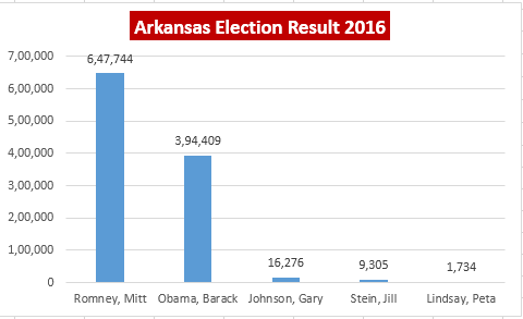
2012
|
Arkansas
|
Romney, Mitt
|
Republican
|
647,744
|
60.57%
|
Winner
|
1.85
|
|
2012
|
Arkansas
|
Obama, Barack
|
Democrat
|
394,409
|
36.88%
|
Runner Up
|
-1.9857
|
|
2012
|
Arkansas
|
Johnson, Gary
|
LIB
|
16,276
|
1.52%
|
||
|
2012
|
Arkansas
|
Stein, Jill
|
GRE
|
9,305
|
0.87%
|
||
|
2012
|
Arkansas
|
Lindsay, Peta
|
SLP
|
1,734
|
0.16%
|
Click on Individual County to get more details about Arkansas's counties Presidential Election Result by Party, Population History, Voter statistics
There are 75 counties in the U.S. state of Arkansas. Arkansas is tied with Mississippi for the most counties with two county seats, at ten.
| County | FIPS County Code | County seat | Established | Origin | Population | Area |
| Arkansas County | 1 | De Witt and | 1813 | 1st County (Eastern Arkansas) | 19,019 | 988 sq mi |
| Ashley County | 3 | Hamburg | 1848 | Chicot, Drew and Union counties | 21,853 | 921 sq mi |
| Baxter County | 5 | Mountain Home | 1873 | Fulton, Izard, Marion, and Searcy counties | 41,513 | 554 sq mi |
| Benton County | 7 | Bentonville | 1836 | Washington County | 2,21,339 | 843 sq mi |
| Boone County | 9 | Harrison | 1869 | Carroll and Marion counties | 36,903 | 591 sq mi |
| Bradley County | 11 | Warren | 1840 | Union County | 11,508 | 651 sq mi |
| Calhoun County | 13 | Hampton | 1850 | Dallas and Ouachita counties | 5,368 | 628 sq mi |
| Carroll County | 15 | Berryvilleand | 1833 | Izard County and later by Madison County (1870) | 27,446 | 634 sq mi |
| Chicot County | 17 | Lake Village | 1823 | Arkansas County | 11,800 | 644 sq mi |
| Clark County | 19 | Arkadelphia | 1818 | Arkansas (1818) | 22,995 | 866 sq mi |
| Clay County | 21 | Piggott and | 1873 | Randolph and Greene counties, and originally named Clayton before 1875 | 16,083 | 639 sq mi |
| Cleburne County | 23 | Heber Springs | 1883 | White, Van Buren, and Independence counties | 25,970 | 553 sq mi |
| Cleveland County | 25 | Rison | 1873 | Bradley, Dallas, Jefferson counties, and formerly named Dorsey County (from 1885) | 8,689 | 598 sq mi |
| Columbia County | 27 | Magnolia | 1852 | Formed from Lafayette, Hempstead, and Ouachita counties | 24,552 | 766 sq mi |
| Conway County | 29 | Morrilton | 1825 | Pulaski County | 21,273 | 556 sq mi |
| Craighead County | 31 | Jonesboroand | 1859 | Mississippi, Greene, Poinsett counties | 96,443 | 711 sq mi |
| Crawford County | 33 | Van Buren | 1820 | Pulaski County | 61,948 | 596 sq mi |
| Crittenden County | 35 | Marion | 1825 | Phillips County | 50,902 | 610 sq mi |
| Cross County | 37 | Wynne | 1862 | St. Francis, Poinsett, and Crittenden counties | 17,870 | 616 sq mi |
| Dallas County | 39 | Fordyce | 1845 | Clark and Bradley counties | 8,116 | 668 sq mi |
| Desha County | 41 | Arkansas City | 1838 | Arkansas, Union counties, then from Chicot County (prior to 1880), and Lincoln (prior 1930) | 13,008 | 765 sq mi |
| Drew County | 43 | Monticello | 1846 | Bradley, Chicot, Desha, Union counties | 18,509 | 828 sq mi |
| Faulkner County | 45 | Conway | 1873 | Pulaski and Conway counties | 1,13,237 | 647 sq mi |
| Franklin County | 47 | Ozark and | 1837 | Crawford and Johnson counties | 18,125 | 610 sq mi |
| Fulton County | 49 | Salem | 1842 | Izard County and then later from Lawrence County (prior 1850) | 12,245 | 618 sq mi |
| Garland County | 51 | Hot Springs | 1873 | Montgomery, Hot Spring, and Saline counties | 96,024 | 678 sq mi |
| Grant County | 53 | Sheridan | 1869 | Jefferson, Hot Spring, Saline counties | 17,853 | 632 sq mi |
| Greene County | 55 | Paragould | 1833 | Lawrence County and later on by Randolph | 42,090 | 578 sq mi |
| Hempstead County | 57 | Hope | 1818 | Arkansas (1818) | 22,609 | 729 sq mi |
| Hot Spring County | 59 | Malvern | 1829 | Clark County and later from Montgomery County (prior 1880) | 32,923 | 615 sq mi |
| Howard County | 61 | Nashville | 1873 | Pike, Hempstead, Polk, Sevier counties. | 13,789 | 588 sq mi |
| Independence County | 63 | Batesville | 1820 | Lawrence County (1820) | 36,647 | 764 sq mi |
| Izard County | 65 | Melbourne | 1825 | Independence, Crawford counties, and later from Fulton (prior 1880) | 13,696 | 581 sq mi |
| Jackson County | 67 | Newport | 1829 | Lawrence and St. Francis counties | 17,997 | 634 sq mi |
| Jefferson County | 69 | Pine Bluff | 1829 | Arkansas and Pulaski | 77,435 | 885 sq mi |
| Johnson County | 71 | Clarksville | 1833 | Pope County, and a small portion from Madison County (prior 1890) | 25,540 | 662 sq mi |
| Lafayette County | 73 | Lewisville | 1827 | Hempstead County and later from Columbia County (prior 1910) | 7,645 | 526 sq mi |
| Lawrence County | 75 | Walnut Ridge | 1815 | Arkansas and New Madrid (MO) in 1815 | 17,415 | 587 sq mi |
| Lee County | 77 | Marianna | 1873 | Phillips, Monroe, Crittenden, and St. Francis counties. | 10,424 | 602 sq mi |
| Lincoln County | 79 | Star City | 1871 | Arkansas, Bradley, Desha, Drew, and Jefferson counties | 14,134 | 561 sq mi |
| Little River County | 81 | Ashdown | 1867 | Sevier County | 13,171 | 532 sq mi |
| Logan County | 83 | Boonevilleand | 1871 | Franklin, Johnson, Pope, Scott, and Yell counties (Formally named Sarber County) | 22,353 | 710 sq mi |
| Lonoke County | 85 | Lonoke | 1873 | Prairie and Pulaski counties | 68,356 | 766 sq mi |
| Madison County | 87 | Huntsville | 1836 | Washington County | 15,717 | 837 sq mi |
| Marion County | 89 | Yellville | 1835 | Izard County | 16,653 | 598 sq mi |
| Miller County | 91 | Texarkana | 1874 | Lafayette County | 43,462 | 624 sq mi |
| Mississippi County | 93 | Blythevilleand | 1833 | Crittenden | 46,480 | 920 sq mi |
| Monroe County | 95 | Clarendon | 1829 | Phillips and Arkansas counties | 8,149 | 607 sq mi |
| Montgomery County | 97 | Mount Ida | 1842 | Hot Spring | 9,487 | 781 sq mi |
| Nevada County | 99 | Prescott | 1871 | Columbia, Hempstead, Ouachita counties | 8,997 | 620 sq mi |
| Newton County | 101 | Jasper | 1842 | Carroll | 8,330 | 823 sq mi |
| Ouachita County | 103 | Camden | 1842 | Union | 26,120 | 732 sq mi |
| Perry County | 105 | Perryville | 1840 | Conway County | 10,445 | 551 sq mi |
| Phillips County | 107 | Helena | 1820 | Arkansas and Lawrence County | 21,757 | 693 sq mi |
| Pike County | 109 | Murfreesboro | 1833 | Clark and Hempstead counties | 11,291 | 603 sq mi |
| Poinsett County | 111 | Harrisburg | 1838 | Greene, Lawrence counties | 24,583 | 758 sq mi |
| Polk County | 113 | Mena | 1844 | Sevier | 20,662 | 860 sq mi |
| Pope County | 115 | Russellville | 1829 | Crawford County | 61,754 | 812 sq mi |
| Prairie County | 117 | Des Arc and | 1846 | Arkansas and Pulaski counties | 8,715 | 646 sq mi |
| Pulaski County | 119 | Little Rock | 1818 | Arkansas and Lawrence counties (1818) | 3,82,748 | 771 sq mi |
| Randolph County | 121 | Pocahontas | 1835 | Lawrence County | 17,969 | 652 sq mi |
| St. Francis County | 123 | Forrest City | 1827 | Formed from Phillips County | 28,258 | 634 sq mi |
| Saline County | 125 | Benton | 1835 | Independence and Pulaski | 1,07,118 | 725 sq mi |
| Scott County | 127 | Waldron | 1833 | Crawford and Pope counties | 11,233 | 894 sq mi |
| Searcy County | 129 | Marshall | 1838 | Marion County | 8,195 | 667 sq mi |
| Sebastian County | 131 | Greenwoodand | 1851 | Crawford and Scott | 1,25,744 | 536 sq mi |
| Sevier County | 133 | De Queen | 1828 | Hempstead County | 17,058 | 564 sq mi |
| Sharp County | 135 | Ash Flat | 1868 | Lawrence County | 17,264 | 604 sq mi |
| Stone County | 137 | Mountain View | 1873 | Izard, Independence, Searcy, Van Buren | 12,394 | 607 sq mi |
| Union County | 139 | El Dorado | 1829 | Clark and Hempstead counties | 41,639 | 1,039 sq mi |
| Van Buren County | 141 | Clinton | 1833 | Conway, Izard, and Independence | 17,295 | 712 sq mi |
| Washington County | 143 | Fayetteville | 1828 | Lovely County | 2,03,065 | 950 sq mi |
| White County | 145 | Searcy | 1835 | Independence, Jackson and Pulaski counties | 77,076 | 1,034 sq mi |
| Woodruff County | 147 | Augusta | 1862 | Jackson and St. Francis counties | 7,260 | 587 sq mi |
| Yell County | 149 | Danville andDardanelle | 1840 | Hot Spring, Pope, and Scott County | 22,185 | 928 sq mi |